Home | Sitemap | Login
  • Background 
    • About SPARK Foundation
    • About GEC
    • Phases of W.A.T.E.R Project
  • Sungai Way 
    • Geography
    • Land Use
    • Biodiversity Study : Flora of Sungai Way
    • Biodiversity Study : Fauna of Sungai Way
    • Sg Way Rehabilitation Programme
    • Solid Waste Monitoring
    • Business Community Training Programme
    • Sg Way Community River Information Centre
    • Sungai Way Urban River Open Classroom
  • Sungai Penchala 
    • Background
    • Target Groups
      • Local Communities
      • Business Communities
      • Education Institutions
      • Youth Groups
    • Stakeholders
    • Penchala River Information Centre
    • Sungai Penchala Open Classroom
    • Mobile River Care Unit (MRCU)
    • Ongoing Initiatives
  • Sungai Selangor 
    • About WATER Project
    • Project Background
    • Project Partners/Stakeholders
    • Ongoing Initiatives
      • Clay Dyke
      • River Monitoring
      • Thimbles
      • Tree Planting
      • Rain Water Harvesting System
      • ORS Bestari Jaya
      • Taman Suria
    • Upcoming Initiatives
  • Sungai Kinta 
    • Introduction
    • Stakeholders
    • Geography
    • Issues
    • Project Site
      • Sungai Senam
      • Sungai Kledang
      • Sungai Buntong
      • Site Map
    • Target Groups
      • Local Community
      • Schools
      • Business Group
    • Activities
      • Phase I (2012-2015)
      • Phase II (2015-2017)
    • Youth Leaders
    • RCEC
  • Get Involved 
    • Introduction
    • Get Involved A-to-Z
    • Local Community
    • Schools
    • Business Group
    • Be a Volunteer!
  • Resources 
    • Event Calendar
    • Media
    • Materials
      • Informative
      • Newsletters
      • Handbook on Urban River Management
    • Videos
  • Contact Us 
  SUNGAI KINTA

Introduction

Stakeholders

Geography

Issues

Project Site
Sungai Senam
Sungai Kledang
Sungai Buntong
Site Map

Target Groups
Local Community
Schools
Business Group

Activities
Phase I (2012-2015)
Phase II (2015-2017)

Youth Leaders

RCEC

    » Home » Sungai Kinta » Project Site » Sungai Kledang

  Sungai Kledang

 
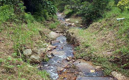
  Sg Kledang near its source at Bukit Kledang, with limpid freshwater running peacefully.
 
 
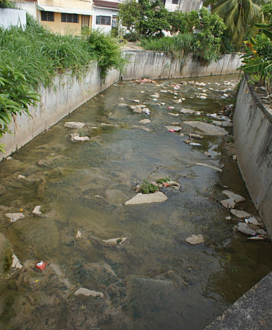
  Litter problem which chokes Sg Kledang together with the effect of sewage
Rising in Bukit Kledang, Sungai Kledang flows for 6.4 km into Menglembu area before entering Sungai Kinta. Sg. Kledang is located at the Menglembu area, concentrated with industrial outlet. There are two contributors for this site which are the residential estate and the industrial. The Sg. Kledang originating from housing estate of Tmn Bukit Kledang indah will meet-up with the industrial area and then flows into the Kinta River. Besides that, communities especially the residents’ attitude were identified as the source factor for the tributaries.

Sungai Kledang endures problems such as sewage, litter or eutrophication. There are number of portions of Sg Kledang that are relatively clean and others that are in need of care. During rapid environmental assessment done by GEC with the assistance of Kinta Department of Irrigation and Drainage (DID), Sungai Kledang at its source at Bukit Kledang is found clean and limpid as land along the upstream is untouched places with minimum development. Between upstream and downstream of Sg Kledang, the changes of character of the river water- physical appearances such as turbidity, colour and odour are substantial.

Solid waste is one of the main factors causing degradation of the Sg Kledang. It not only affects the quality of the water, but also destroys aquatic and botanical life and prohibits the enjoyment of recreational activities(not sure if this is suitable). In certain places, Sg Kledang is clogged with rubbish and in some cases excess litter flow freely in the middlestream and downstream.

 
.


Copyright © 2008 - 2025 Water Project. All Rights Reserved